Trail Walking Les Haies - SityTrail - Echalas 10 a 261 g1 d - Photo

SityTrail - Echalas 10 a 261 g1 d

© OpenStreetMap contributors
Length
Length
10.2 km
Max alt
Max alt
430 m
Uphill gradient
Uphill gradient
262 m
Km-Effort
Km-Effort  
13.6 km
Min alt
Min alt
303 m
Downhill gradient
Downhill gradient
258 m
Boucle
Boucle
Yes
Creation date :
2021-11-11 08:22:07.401
Updated on :
2021-11-11 08:26:48.078

(0 Reviews)

Walking
Walking
3h05
Difficulty : Difficult

Scan this QR Code to open this trail in the SityTrail application

FREE GPS app for hiking

Logo SityTrail SityTrail

IGN / Geographical institutes

Download SityTrail from the App Store Download SityTrail from Google Play

Logo SityTrail SityTrail World

The world is yours!

Download SityTrail from the App Store Download SityTrail from Google Play Download SityTrail on Huawei AppGallery

About

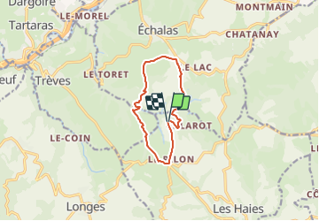
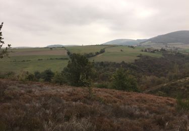
Trail Walking of 10.2 km to be discovered at Auvergne-Rhône-Alpes, Rhône, Les Haies. This trail is proposed by jtraverse.

Description

GPS :
45°31'39.5"N 4°43'17.0"E ou 45.527636, 4.721374
69420 Les Haies

Elevation profile

Positioning

Country:
France
Region :
Auvergne-Rhône-Alpes
Department/Province :
Rhône
Municipality :
Les Haies
Location:
Unknown
Start:(UTM)
634419 ; 5043008 (31T) N.

Trails nearby

Trail Walking Trèves - Chemin de Fer à Trèves - Photo
Walking
tracegps

Walking

Medium
(1)
Trèves, Auvergne-Rhône-Alpes, Rhône, France
4.5 km | 6.8 km-effort
1h 30min
Yes
Trail Walking Échalas - 69-echalas-17km-450m - Photo
Walking
SyMA

Walking

Difficult
Échalas, Auvergne-Rhône-Alpes, Rhône, France
17.4 km | 23 km-effort
5h 17min
Yes
Trail Walking Longes - 1 septembre 2022 longes - Photo
Walking
Parodie69

Walking

Difficult
Longes, Auvergne-Rhône-Alpes, Rhône, France
23 km | 35 km-effort
6h 40min
Yes
Trail Walking Longes - 69-longes-Mont-Monnet-Ste-Croix-Jarez-20km-800m - Photo
Walking
SyMA

Walking

Difficult
Longes, Auvergne-Rhône-Alpes, Rhône, France
20 km | 31 km-effort
6h 5min
Yes
Trail On foot La Chapelle-Villars - Pilat N°30: des «Côteaux à les Haies» - Photo
On foot
PRO

On foot

Difficult
La Chapelle-Villars, Auvergne-Rhône-Alpes, Loire, France
29 km | 37 km-effort
8h 27min
Yes
Trail Walking Échalas - Rando à Echalas - Photo
Walking
tracegps

Walking

Medium
(1)
Échalas, Auvergne-Rhône-Alpes, Rhône, France
21 km | 29 km-effort
5h 0min
Yes
Trail Walking Trèves - Randonnée de Trèves à Dizimieux - Photo
Walking
tracegps

Walking

Medium
Trèves, Auvergne-Rhône-Alpes, Rhône, France
7.2 km | 10.3 km-effort
2h 0min
Yes
Trail Other activity Longes - Longes - Ste Croix en Jarez - Photo
Other activity
maelow

Other activity

Easy
Longes, Auvergne-Rhône-Alpes, Rhône, France
17.1 km | 24 km-effort
3h 10min
Yes
Trail Other activity Longes - Longes - Ste Croix en Jarez - Photo
Other activity
maelow

Other activity

Easy
Longes, Auvergne-Rhône-Alpes, Rhône, France
17.1 km | 24 km-effort
3h 10min
Yes


Close
My subscriptions